A Placemaking Journal
Balancing the Scales of City Sustainability
I spend virtually all my professional time thinking about the intersection of human settlement and environmental sustainability. I am particularly interested in the built environment of American cities, towns, and suburbs – what I like to call our “people habitat” – and how it relates to the natural world. How can we make these two realms – people habitat and natural habitat – more harmonious?
These issues are acutely on my mind today because I am preparing a talk I have been invited to deliver early next month on “Urbanism and Sustainability.” (For those who are interested, it will be at the annual meeting of the Congress for the New Urbanism, in Detroit, at 10.15 am on June 8.)
The scales of urban sustainability
I suppose I should start by defining what I mean by “environmental sustainability.” I generally use the phrase in its colloquial sense, to mean environmental health. More formally, most scholars start with the definition of sustainable development in the international treatise Our Common Future, also known as the Brundtland Report:
“Sustainable development is development that meets the needs of the present without compromising the ability of future generations to meet their own needs.”
Or, as my friend Steve Mouzon eloquently puts it, “can we keep things going in a healthy way, long into an uncertain future?”
In thinking about city sustainability, I find it useful to focus on two important geographic scales: the region, generally defined as the metropolitan region; and the neighborhood. Both matter a great deal.
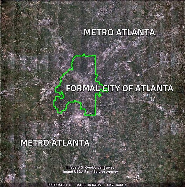
First, the economies of our “cities” operate in reality at a metropolitan geography, without regard to the formal jurisdictional boundaries of specific cities, suburbs, towns, and counties; same with our commuting patterns and transportation systems. Metropolitan Cincinnati, shown in the photo at the top of this article, appears seamless in the image; but in fact we are looking from the Kentucky side of the Ohio River and viewing a wide range of legally separate municipalities in two states. Metropolitan Atlanta (partial satellite view below), as defined by the Census, is about 12 times more populous than the formal city of Atlanta and a staggering 62 times larger in area.
Sometimes our thinking needs to address areas even larger than metro regions. The health of our waterways, in particular, is determined by what happens within their watersheds, which can be massive: The Chesapeake Bay watershed encompasses some 64,000 square miles in parts of six states and the District of Columbia.
Because people, goods, and services – and, significantly, environmental media such as air, water and energy – cross jurisdictional boundaries all the time, what happens in one part of a region can profoundly affect what happens in another part. We cannot have sustainable cities and towns if their surrounding regions are not sustainable.
Second, even if a region as a whole has the empirical markings of sustainability, it will not be a place in which many of us want to live if its component neighborhoods are not also healthy, hospitable and attractive. Simply put, neighborhoods are where we encounter our environment on an everyday basis. They are the places that matter the most to us, and that affect our health and well-being most directly.
Neighborhoods are also where increments of change place, and thus where we must pay attention and where we can most easily make a difference. This goes for commercial and mixed-use neighborhoods as well as for residential districts.
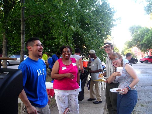
If metro regions represent the economic scale of people habitat, neighborhoods represent the human scale. We have to get them both right.
Growth challenges ahead
All sorts of neighborhoods – and all sorts of regions – are going to be facing pressure over the next several decades. This is because the overwhelming majority of American metro areas – collectively, where some 85 percent of us live – are going to be experiencing substantial growth. While the expansion will occur in some parts of the country more dramatically than in others – the Phoenix and Tucson metros are projected to more than double in population from 2010 to 2050, while the Great Lakes region is projected to add “only” about 28 percent to its population in that period – the challenges faced across the country in accommodating growth will differ mainly as a matter of degree.
By now, we know all too well how not to do it: In the late 20th century and, in many places, continuing into the 21st, we allowed population, jobs, and investment dollars to sprawl across the countryside, quite literally in search of greener pastures on which to build as we allowed our older neighborhoods and towns to deteriorate. The result of this rampant spreading out was desecration of the landscape as farms, forests, and watersheds were paved over; massive growth in motor vehicle traffic and accompanying pollution as we had to drive longer and longer distances to get things done; increased strain on municipal budgets as infrastructure and service dollars were spread too thin; and economic and social stress for populations left behind, all too often in pockets of concentrated poverty.
In order to have any chance at achieving sustainability in the face of growth, we must do things differently. We must use land more efficiently, building whenever we can at walkable densities on vacant and underutilized land within the existing development footprint. We must put more people within convenient reach of jobs, shops and amenities and close to comfortable and reliable transportation options.
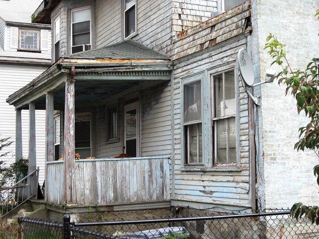
Where our older communities and neighborhoods have been weakened, we must strengthen them. Where our newer suburbs have been built haphazardly, we must take advantage of opportunities to revisit their configuration and make them work better. Where our natural and rural environment has been threatened, we must take care to conserve it. (Same with the built historic fabric of our cities and towns, by the way.) Where constituencies have been left out of planning and development decisions in the past, we must include them.
These are the values that underlie what some of us call urbanism, what others of us call quality growth or smart growth. Urbanism is generally very helpful to the environment at both the regional and the neighborhood level.
At the regional scale, urbanism is a terrific asset to sustainable growth management; more compact development patterns create a range of efficiencies that lower the per-capita impacts of regional growth in comparison to sprawl. At the neighborhood scale, walkability brings considerable public health benefits and obviates what might otherwise be motor vehicle trips. Urban and walkable suburban living is popular in the marketplace, too; demand for urban living is growing. Indeed, a new analysis of real estate data published in The Washington Post shows that city and inner suburban neighborhoods across the country are rising in value much faster than their outer suburban counterparts.
But it is also a bit more complicated at the neighborhood scale: unless mitigated and managed very carefully, some of the local environmental consequences of urbanism can actually be negative rather than positive.
The geography of impacts from traffic
Compare, for example, the two color-coded maps of metropolitan Philadelphia, below. The one on the right shows greenhouse gas emissions per capita from transportation. The green areas on the map indicate the parts of the region where per-capita emissions are the lowest; they are concentrated in Center City Philadelphia, inner suburbs, and other urban centers sprinkled around the region. This is consistent with research showing that people who live in relatively central and relatively dense locations do not drive as far or as often, on average, as people who live in more sprawling locations, shown on the map in red.
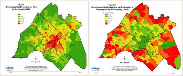
If you are a regional planner looking to reduce growth in traffic and associated emissions, you want to concentrate as much new growth as possible in those green locations where per-capita impacts are relatively low, and to retrofit the yellow and red locations with less sprawling, more walkable and, yes, denser development so that their performance improves over time.
But take a look also at the map on the left. This one shows not emissions per household but emissions per acre, and in this case the more urban places are the ones in red. This map is telling us where environmental impacts from traffic are greatest and that density, notwithstanding its per-capita advantages, can bring more traffic and along with it more tailpipe emissions to some places. If you are a resident of a neighborhood destined for more urban, denser development, and you are fearful that the proposed development will bring more congestion and more pollution, the map on the left is suggesting that your fears may not be irrational.
Similar issues for watersheds
There is a similar dynamic going on with respect to runoff water pollution from development. In particular, the volume of stormwater runoff flowing into receiving waters during a rain event tends to vary with the amount of impervious surface (mostly pavement and rooftops) in the watershed: the greater the amount of impervious surface, the more pollution. This is because impervious surfaces prevent water from filtering into the ground gradually, forcing it instead to “run off,” picking up contaminants along the way.
Just as with motor vehicle traffic, development density lowers per-capita impervious surface, and thus runoff volume, in the watershed compared to large-lot sprawl. While this may seem counterintuitive because large lots might be thought to have more lawn and forested area and thus more absorbent ground cover, the additional perviousness within each individual lot is not enough to overcome the large amount of impervious surface imposed by the longer, wider roadways and bigger surface parking lots associated with sprawling development. Faced with a growth scenario, an environmentally conscious regional planner thinking about watershed health might want to encourage compact development and discourage sprawl.
But, again, the wrinkle is that density, unless mitigated, tends to increase local, per-acre imperviousness. Here is another set of maps, this time from Seattle:
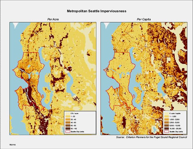
Note how the per-capita imperviousness is greatest in the outlying, more sprawling parts of the region, while the per-acre imperviousness is greatest in the central, more densely developed parts. The latter is one of the reasons why urban waterways tend to be more polluted than rural ones, and one of the reasons while restoring the health of our nation’s urban waterways (and their often-overloaded sewer systems) can be so challenging.
So, where does this take us?
If you are looking for easy answers to resolving this fundamental dilemma – what I call in my book “the environmental paradox of smart growth” – you will not find them here. The hardest challenge a planner or other responsible official attempting to manage growth might face is to strike an appropriate balance between sometimes legitimately competing concerns, and the challenge must be met with collaboration, empathy, sophistication, and creativity. I might even argue that finding the right balance in the right situations is what the city planning profession is for.
We do have tools with which to work: With regard to motor vehicle traffic, we can take steps to mitigate potential increases in traffic volume and its associated harms (which include noise as well as congestion and air pollution) with increased coordination of development with non-motorized transport modes such as walkability, bicycle facilities, and good transit service. I find it hopeful that recent research suggests that traffic generated in urbanizing locations is not nearly as bad as traditional engineering theory might suggest. And there are models to emulate: Indeed, in my own region Arlington, Virginia has had great success adding considerable density to a transit corridor without the great increases in traffic that some predicted. More generally, the Washington, DC metro region as a whole grew in population by 14 percent between 2007 and 2015 while increasing motor vehicle traffic by only one percent.
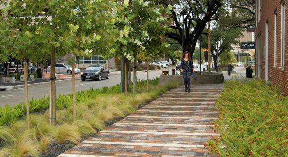
With regard to stormwater pollution, I am very encouraged by the rapidly evolving field of green infrastructure: by using techniques such as strategically designed tree plantings and landscaping, green roofs, rain gardens, pervious pavement, and rain barrels, we can capture stormwater even in highly urban settings and allow it to filter into the ground before it becomes polluted runoff and contaminates receiving waterways. Pocket parks and community gardens can be part of the solution, too. What I love most of all about green infrastructure is that in addition to its water quality benefits it brings nature and badly needed green space into dense urban neighborhoods, making them simultaneously more sustainable and more lovable.
I also think that moderation can be part of the answer. Intensive development has its place; but, as I have written before, I love the idea of walkable neighborhoods that retain a human scale, and I believe the concept holds a lot of promise for bringing us the best of both worlds in the right situations. We do not need to duplicate Manhattan or Hong Kong densities to show substantial improvements in environmental performance over sprawl.
On this point, I find it encouraging that there is a growing movement in architectural circles to promote a smaller-scale, more incremental approach to urbanism. The idea is that real estate development in the US has come to be dominated by Big Projects backed by Big Financing; and smaller-scale, more incremental approaches that can strengthen neighborhoods without overwhelming them have become rare. Thought leaders such as Dan Parolek and John Anderson are working to turn that around, quietly building a constituency and a national portfolio of successful smaller projects, spreading the word in workshops around the country. Think small-scale infill such as two- and three-story, multi-family buildings often found side-by-side with single-family homes in older neighborhoods across the country.
(For more on the subject, my PlaceMakers colleague Ben Brown wrote an introduction to incremental development here, and Amanda Kolson Hurley has written a great article about the movement for Next City.)
Ultimately, the answers to sorting out these conflicts must be situational, matching the right densities and the right mix of urban design features and mitigation to the right places. And they will require the very best in our thinking and creativity. Let’s keep moving forward with urbanism, but let’s also keep working on making it as good – and as sustainable – as we can.
Originally featured on the Huffington Post. Reprinted here with Kaid’s permission. Move your cursor over the images for credit information.
–Kaid Benfield
If PlaceShakers is our soapbox, our Facebook page is where we step down, grab a drink and enjoy a little conversation. Looking for a heads-up on the latest community-building news and perspective from around the web? Click through and “Like” us and we’ll keep you in the loop.


